A number of hiking and running events are scheduled across the Southeast in December. There are more Jingle Bell Jogs than any other running event–over 25 of them are scheduled across the region. But you don’t necessarily need an organized run or hike to dedicate your miles; you can enjoy a family walk around the neighborhood or a stroll over the river and through the woods this holiday season–and donate the total mileage to Miles for Mountains. Even your estimated mileage walking through the shopping malls can count toward our goal of one million miles for mountaintop removal. As of December 3, we’ve collected 91,224 miles. Keep ’em coming.
Give Thanks, Give Miles
November 13, 2009 - One Response
Total miles as of November 12: 83,844.
The miles continue to roll in from across the country…thanks to everyone who dedicates their exercise, whether it’s a few miles at the gym or dozens of miles out on the trail. The miles are adding up—and so is the pressure to end mountaintop removal mining. Lisa Jackson, head of the EPA, recently suspended all mountaintop mining permits to determine if they are violating the Clean Water Act. More people than ever are mobilized to end mountaintop removal. Unfortunately, the coal industry is accelerating its efforts; they have recently begun blasting on Coal River Mountain, a beloved mountain in West Virginia. Residents nearby overwhelmingly support a wind farm on the mountain, but Massey Energy is continuing its daily dynamiting of the mountaintop. Find out more here.
As we approach the Thanksgiving holiday, consider burning off calories with a brisk walk or run around the block—and then emailing your mileage (even if it’s just a quarter-mile) to milesformountains@yahoo.com (or posting it in the comments below). It’s free. It’s meaningful. And it can save lives—including your own.
Monthly Mileage Update
October 4, 2009 - Leave a Response
Total miles donated has jumped to 41,082 as of October 1.
Thanks especially to Alan Zaslow–and his dog, who donate their daily 3.5-mile walks in Maryville, Tennessee. Missouri deputy sheriff Darrin Layman just completed his first half-marathon and has donated all of his training and racing mileage. Brandon Early and his wife have been donating their weekly hiking and running mileage. And a big thanks to Julianna Warner, a cross country runner with Davis & Elkins College in West Virginia. Julianna donated all 179 miles of her cross country season to Miles for Mountains.
We really appreciate all the donations of miles rolling in—the daily treadmill walks and the weekend backpacking trips, the group runs around the block and the trail runs in the woods. Every mile matters.
Miles for Mountains in C-Ville Weekly
October 4, 2009 - Leave a Response
Thanks to Erika Howsare for this great story in “The Green Scene” of C-Ville Weekly, a leading independent newspaper in Charlottesville:
|
by Erika Howsare
I’ve heard running called “self-centered,” and indeed it is usually a pursuit that one takes up for one’s own satisfaction and health, not for the greater good. I, for one, feel like I’m giving myself a treat when I head out for a run—quite a different state of mind than when I attack a pile of dirty dishes or a backlog of e-mails. So I say thank you, Will Harlan, for adding a dimension of noble altruism to the self-centered pursuit. Harlan—who edits the locally-produced Blue Ridge Outdoors magazine—is one of these crazy-person ultramarathoners whose runs sometimes take more hours than most of us are awake on an average day. This summer he ran 72 miles along the Appalachian Trail in Great Smokies National Park and set a speed record doing it (just under 17 hours! Good Lord!). More importantly, he wanted his run to make people more educated about mountaintop removal mining (MTR). You can read an account of the run here, and while you’re at the site you’ll surely notice that Harlan is asking people to donate their own miles—whether run, walked, or hiked—toward a goal of one million miles to end MTR. Why? Harlan explained in an e-mail: “Many hikers, walkers, and runners have no idea that over 500 mountains have been blown up, and another 79 are slated for mountaintop removal in the next few years. Since a lot of folks don’t have money to donate right now, Miles for Mountains enables them to donate their miles—miles that they probably would have covered anyway. It gives meaning to their miles and purpose to their pain.” Hear, hear. When the goal of a million miles has been reached, Harlan says he plans to trek by foot from the coalfields of southern Virginia to D.C. to “deliver the miles to Congress and the White House.” I can see that being a powerful message: all those miles covered by average citizens, two or five or 10 at a time. I’ll happily donate mine. Who else is in?
|
|
|
In the Footsteps of Daniel Boone
September 30, 2009 - One Response
Twelve years ago, Kentucky hiker Shad Baker had a dream: to create a long-distance hiking trail in eastern Kentucky that rivaled the classic footpaths of the Smokies. He hoped that such a trail would enable hikers to walk in the footsteps of the legendary Kentucky pioneer Daniel Boone through a wild, primitive landscape.
So Baker began talking to friends, organizing volunteers, and floating the idea to various state and federal land agencies. After years of meetings and negotiations—and then years of land acquisitions and fundraising—and then several more years of building and blazing the footpath—Baker has turned his dream into a 44-mile reality.
The Pine Mountain Trail is the longest in Kentucky, and it crosses the state’s second highest mountain. Yet few people have ever stepped foot on it. Last Friday, I decided to trek from its eastern terminus near Elkhorn City, Ky., to its western trailhead near Whitesburg.
From Elkhorn City, the footpath climbs steeply up to the Pine Mountain ridgeline, where it undulates between 2500 feet and 3500 feet for most of the journey. ATV trails criss-cross the footpath for the first few miles, and graffiti mars ancient caves and rock formations.
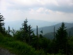
But at Skeet Rock Knob, the first major summit, I was rewarded with a jaw-dropping view of the eastern Kentucky mountains.
Water is scarce along the trail, so I made sure to stop at Jenny Falls, a cascade just before the Birch Knob Tower. A mile later, at Birch Knob Observation Tower, I soaked in another eastern Kentucky panorama. I thought to myself, This is what Daniel Boone must have seen…except for the beheaded mountains. Mountaintop removal sites encroach upon the Pine Mountain Trail from all sides.
From Birch Knob, the trail follows a gravel road for about a mile before it re-enters the forest near Mullins Pond and continues to roll along the ridgeline.
Only one other road crosses the entire stretch of the Pine Mountain Trail: four-lane U.S. 23 at Pound Gap. A gas station there provides a convenient place to restock before embarking upon the 15-mile Highland section. The first six miles of this section are pristine, well-manicured singletrack that rolls through deep, lush forests. However, after Rose Gap, the trail bed disappears, and hikers are left to bushwhack for a few miles. I followed yellow blazes from tree to tree, slashing through overgrown thickets. Baker and the Pine Mountain Trail Conference plan on re-building this section of trail with the help of a Sierra Club volunteer trail crew in October. In the meantime, the bushwhack will challenge even the most experienced hiker’s navigational skills.
Finally, the trail emerges onto a razor-thin section of exposed sandstone. The stunning vistas from the narrow ridgeline trail make the bloody-shinned bushwhack worth the effort. For the final five miles, the trail crosses several sections of exposed rock, offering views that can only be described as stunning. Amid the rolling green waves of mountains were the brown deserts of mountaintop removal sites. Not until I stood atop High Rock and looked out across the mountains—many still intact, many decapitated by mountaintop removal—did I realize eastern Kentucky was so beautiful…and so vulnerable.
Fortunately, Pine Mountain’s unqiue geology has spared it from mountaintop removal mining. Pine Mountain is an overthrust fault, which means that layers of rock from deep below the Earth were in such strong compression that one side of the layers broke and slid up and over the other, according to Roy Crawford, president of the Pine Mountain Trail Conference and one of the founders of the trail.
“If you hold your hands flat and vertical in front of you with your fingertips touching, then slide one hand up over the other, you’ll have a side view of the geology of Pine Mountain, with different fingers being shale, sandstone, and limestone,” explains Crawford.
The rocks of Pine Mountain were formed millions of years before coal was, meaning they were much lower in elevation, continues Crawford. Whatever coal may have been on top of Pine Mountain has eroded off.
Thanks to geology, time, and the sweat labor of volunteers like Crawford and Baker, the 44-mile footpath across Pine Mountain is one of the most spectacular hiking experiences in Appalachia. But all around the trail, mountaintop removal is encroaching on the ancient mountain—leveling nearby mountaintops, destroying scenic views, and poisoning the health of eastern Kentucky residents below.
The Next End-to-End Run to End Mountaintop Removal
September 11, 2009 - Leave a Response
Elite runner Will Harlan plans to run the entire length of the 44-mile Pine Mountain Trail next Friday. The Pine Mountain Trail is the newest long-distance trail in the Appalachians, and it crosses the second-highest mountain in Kentucky, Pine Mountain.
Last year volunteers completed construction of the first 44 miles of the Pine Mountain Trail from Elkhorn City to Whitesburg. Eventually they hope to build trail all the way to Cumberland Gap, where it will connect with Tennessee’s 330-mile Cumberland Trail.
Appalachia’s newest trail is also the most endangered. Mountaintop removal mining sites abound on either side of the narrow Pine Mountain ridgeline. The dramatic views from the Pine Mountain Trail are scarred by the flattened brown rubble of mountaintop removal sites.
Harlan hopes his run will help bring an end to mountaintop removal.
“Mountaintop removal destroys the health of communities and their economies,” says Harlan. He notes that wind energy now employs more people than coal today in the United States, while highly mechanized mountaintop removal operations employ only a few people.
Earlier this year, Harlan ran the entire 72-mile length of the Appalachian Trail through Great Smoky Mountains National Park, setting a new speed record of 16 hours, 53 minutes. His Smokies record run was also dedicated to ending mountaintop removal.

Total Miles Donated So Far
August 12, 2009 - Leave a Response

Miles for Mountains has received 32,432 miles donated so far from runners, walkers, and hikers all across the country. Special thanks go out to Darin Layman, a runner in the Ozarks of Missouri, who has donated over 92 miles in the past six weeks. Steven McBride, a professional photographer from Asheville, N.C., and his partner Sharon donated their 70 miles of hiking in Glacier National Park last month. Several ultra runners, track clubs, mom’s walking groups, and high school teams have also joined the effort. Thanks to everyone for their continued support and willingness to share their miles for an important cause: protecting mountains that are older than life on earth.
Submit your mileage on a daily, weekly, monthly, or periodic basis to milesformountains@yahoo.com or post them to the web site. Our goal: one million miles to end mountaintop removal. We’re getting there, one step at a time.
Smokies Run story in Asheville Citizen-Times
July 5, 2009 - Leave a Response
 Click here to read the short story about the Smokies Run to End Mountaintop Removal in the Asheville Citizen-Times. Thanks to Karen Chavez for her help.
Behind the Scenes of Will’s Smokies Run
June 28, 2009 - 2 Responses
Chris Weller provided logistical support for the End-to-End Smokies Run to End Mountaintop Removal. This five-minute video captures his observations from the trail.
End-to-End…to End Mountaintop Removal
June 26, 2009 - 6 Responses


Yesterday, I completed a 72-mile, end-to-end run across Great Smoky Mountains National Park in just under 17 hours, a speed record. However, the real goal was to help bring an end to the devastating and deadly effects of mountaintop removal mining in Appalachia.
I followed the Appalachian Trail (A.T.) for the entire run. The Smokies section of the A.T. is one of the toughest trails in the country: the steep, boulder-strewn footpath climbs sharply up 6,000-foot summits, including an ascent of Clingmans Dome, the highest mountain on the A.T.
But the trail’s difficulty is surpassed by its beauty: it abounds with lush old-growth forests, dramatic vistas, and an unsurpassed array of wildlife—especially bears. An estimated 1,500 black bears reside in Great Smoky Mountains National Park.
I had attempted a Smokies end-to-end run six years ago and barely survived. A pollution-induced asthma attack during the run stranded me on the trail. Ironically, my run was intended to promote clean air, but the orange-alert ozone day in the Smokies that summer day had constricted my chest and airways, leaving me wheezing and unable to walk 10 feet without stopping to catch my breath. By nightfall, I had stumbled across an open bald before nearly colliding with a bear in the moonless, dark night. Without a headlamp, I used the glow light of my watch to read a trail sign pointing the way to Spence Field shelter, where I was able to get water and rest. By morning, pollution levels in the park had fallen and my breathing had recovered, and I was able to finish the run.
But my wife suffered even more than I had on that run. She had hiked in to meet me at a shelter along the trail to provide food, water, and a headlamp, but when I did not arrive that night, she feared the worst. She spent a sleepless night at the shelter, where she was visited by a large bear, wondering whether I was lost, mauled, or dead. We tearfully reunited at Fontana the next morning, but the pollution-induced respiratory attack had profoundly shaken me.
However, I wasn’t going to let coal-fired power plant pollution keep me away from the Smokies forever. Six years later, I decided to return for another end-to-end run. This time, I was running to help bring an end to mountaintop removal mining, in which coal companies blow up Appalachian mountains and dump the toxic debris into adjacent streams. Cancers and diseases are rampant in mountaintop removal areas. Dozens of mountain communities have been destroyed, 1,200 miles of rivers have been buried and poisoned, and 470 mountains have been beheaded. Another five proposed mountaintop removal sites are within 50 miles of Great Smoky Mountains National Park.
On June 25, 2009, I began my run across the Smokies to end mountaintop removal. Just two days earlier, Daryl Hannah, NASA scientist Dr. James Hansen, and dozens of other activists were arrested at a mountaintop removal protest. I hoped my journey could educate visitors to the most visited—and most polluted—national park in the country about the devastating health impacts of mountaintop removal.
My friend, Chris Weller, dropped me off at Davenport Gap on the eastern edge of the Smokies at 5am. In the dark, I carried a small flashlight to guide me up the muddy trail towards Mount Cammerer. I also had a fanny pack with two water bottles and a third hand-held bottle, since I would be on my own for most of the day and temperatures were expected to climb quickly into the high 80s.
By mile 3, I felt blisters forming on my heels. I couldn’t believe it. My feet rarely blister, but I was wearing relatively new shoes, and I had kicked a lot of grit from the wet, muddy trail into the heels of the shoes. I was also hiking steeply, and the sharp angle of my feet in the shoes also may have encouraged the blisters to form. Regardless, I was pretty frustrated.
To keep my mind off the pain of the blisters—and the thought of 70+ miles with blistered heels—I sang children’s songs. My one-year-old son River was on my mind, so I sang one of his favorites, “Peace Like a River,” all the way to Cammerer. Keeping a peaceful, fluid running form—and attitude—would be critical to reaching the finish, so I kept the musical mantra in my mind all day.
The blisters worsened as they broke open and rubbed raw, but I kept focused on the beauty around me, especially the lush forests and cool breezes rolling off 6,000-foot Mount Guyot. I soon reached Tri-Corner Knob and refilled my water bottles at a trailside spring. My good friends Mark and Anne Lundblad had encountered a large bear at Tri Corner Knob just a few weeks earlier, so I said a quick prayer of thanks to the bears and other creatures who were allowing me to pass through their home.
The blisters were less painful on downhills, so I sailed briskly down to Pecks Corner and again refilled water bottles. From here began a long waterless stretch across a narrow ridgeline—called the Sawteeth because the thin jagged ridge dropped precipitously on either side. I soaked in the incredible views of North Carolina to the left and Tennessee to the right, with the narrow, briar-choked trail straddling the state line.
The sun was blazing high in the sky now, so I pulled out my hat and dug in for several climbs up to Icewater Spring, then danced down the boulder-lined trail into Newfound Gap.
It had taken me 7 hours, 10 minutes to reach Newfound Gap. Chris was waiting in the parking lot wearing his END MOUNTAINTOP REMOVAL t-shirt and distributing information to the hundreds of hikers congregated there. I refueled quickly and left Newfound Gap five minutes later, eager to tackle one of the toughest climbs of the day—the eight-mile trek to Clingmans Dome.
My blisters had been pounded into an uncomfortably numb state. I was reminded of their presence with each step, but I was not debilitated by the pain. I kept a steady pace in the midday heat, careful not to overexert myself and trigger a respiratory attack. On this hot summer day, pollution levels were again expected to reach a code orange alert. This time, I was taking ibuprofen to help keep reduce bronchial inflammation and keep my airways open.
Two hours later, I arrived atop Clingmans Dome and eagerly plunged down the back side. I felt a renewed vigor as I slalomed down to Double Spring Shelter and summited Silers Bald. But soon the mid-afternoon sun and heat took its toll, and by the time I began the approach to Thunderhead Mountain, my pace began to slow. The ascent of Thunderhead featured the steepest, rockiest climbs of the entire trail, including a few sections where I used all-fours to scramble up. The descents were equally sharp, with jagged boulders poking out of the trail. I clambered up numerous false summits, only to see the dark shadow of Thunderhead high in the distance.
I had failed to refill my third water bottle at Derrick Knob Shelter, so I soon ran out of water on the climb to Thunderhead. When I finally reached the wooden sign at its summit, I had another couple of miles across overgrown, deeply rutted, ankle snapping trail to Rocky Top and then Spence Field. The sun baked the exposed, open balds, slaking my thirst and reducing my pace to a trudge. And my chest was tightening and my breathing was getting shallow.
I finally hopped down the water-bar lined trail and arrived at Spence Field, where Chris had hiked in to meet me with food, water, and a headlamp. I checked my watch: 6:30pm. I still had 17 miles to go, and only two more hours of daylight. I forced myself to eat a muffin and some strawberries before dragging my body back onto the trail. I was hot, hungry, nauseated, oxygen-deprived, and dispirited.
Then I saw the sign…the Spence Field Shelter sign I had read by watch-light that probably saved my life six years ago. Suddenly all of the emotion from that experience came flooding back. I picked up my pace on the dirt-packed downhill to Russell Field Shelter, where my wife had been stranded. Soon I was flying toward Mollie’s Ridge. I was pouring everything I had into running fast, smooth, and peaceful, like a river. I wanted to cover as many miles as possible before dark, so I pushed myself up Mollie’s Ridge and then Doe Knob. But I had run out of water again, and still had 7 miles to go. I made it to Birch Spring a few miles later and could hear a wheezing in my throat as I scampered down a side trail to refill my water bottles one last time.
It was completely dark now. I strapped on my headlamp, whose beam was not very strong, so I ended up holding it my hand for the final five miles. A few sneaky hills still remained, including a steep ascent up to Shuckstack. My legs were badly beaten up from the fast pace, but I slung my body up Shuckstack and began the screaming four mile descent to Fontana. I could barely see the trail with my faint headlamp, and I was moving as nimbly as I could over rocks and roots on the sharply turning trail. My quads and knees were getting pounded by the fast pace. My blistered feet were on fire. I checked my watch and saw that a sub-17 hour finish was possible. But I could not go any faster with the limited vision I had. One time, I let my body accelerate on a steep downhill only to fly off the side of the trail and crash into a briar patch; another time, I opened up my stride a bit and started really flying, only to stumble down a sudden drop in the trail and nearly face-plant into a boulder. I could see the lights of Fontana Dam, but the punishing trail continued to snake down the ridge in a seemingly endless series of switchbacks.
There were several blowdowns in the final two miles, including a giant tree with all its leaves and branches blocking the trail for about 50 feet. I slashed through the tangle of limbs, but could not find the trail on the other side. I continued to wrestle through the branches, searching for the trail, which had twisted sharply above me. I clambered back onto to the trail continued pounding downhill.
Finally the trail spit me out onto the paved road leading to Fontana. After several miles of bracing down the dark downhills, I opened up my stride and let it rip. The lights of Fontana Dam glowed through the trees and glistened off the lake. I poured everything I had left into the final stretch and finished in 16 hours, 53 minutes. I found out later that my time had tied the speed record; Knoxville elite runner Bob Adams ran exactly the same time just a few months earlier this year.
Afterward, I lay on the concrete beside the visitor center and listened the sound of the water pouring over the dam. A sliver of moon hung over the lake. I soaked up the starlight and the silhouette of the mountains.
Just a few miles away, mountains as beautiful as these were being dynamited and dumped, poisoning the communities that live near these operations—just to get at the last remaining seams of coal. My 72-mile run would probably do nothing to stop more mountains from being beheaded and more people from dying. I never felt so small. And at the same time, in the shadows of ancient mountains, I never felt more inspired to keep fighting.
For more information about mountaintop removal mining and your connection to it, visit ilovemountains.org.
